OVERVIEW:
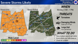
As the short-range models have come in, confidence has increased that a line of strong to severe storms will impact east Alabama and West Georgia early Monday morning through Monday evening. Stay tuned for additional updates.
EARLY MONDAY MORNING TO EARLY MONDAY AFTERNOON:
· Timing has been fine-tuned regarding the line of strong to severe storms that will push into northeast Alabama and extreme northwest Georgia between 5 AM to 7 AM Monday, before pushing southeast across the area.
· SPC now has an Enhanced Risk (level 3 out of 5) for severe weather across east Alabama and west Georgia as the line of storms moves through.
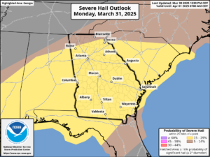
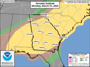
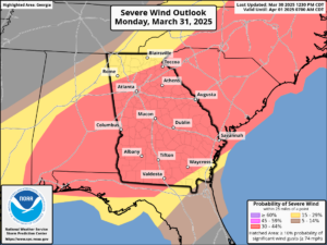
· Damaging wind gusts, hail, and tornados are all possible. See SPC threat graphics below.
· A rough timeline for the line of storms for our area is 5:00 am to 11:00 am
HAZARDS AND IMPACTS:
Early Monday morning to early Monday afternoon
· Damaging wind gusts could lead to downed trees and powerlines.
· Severe hail (1″ or greater in diameter) is possible.
· Brief tornadoes are possible.
FORECAST CONFIDENCE:
· Confidence in the occurrence of storms is high.
· Confidence in the timing and magnitude of the severe threat is medium to high.